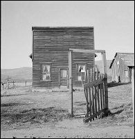
Welcome to Gem County!
Historical Background
Prospectors and miners moved through this county in 1862 enroute to the gold rush in the Boise Basin to the east. By the next year irrigation begain along the Payette River as farmers raised crops to sell in the mining camps.
In late summer of 1862 Tim Goodale brought his wagon train through the valley, crossed the Payette River, followed Haw Creek into the foothills to the north, crossed Willow Creek (Payette County) traveled up Four-Mile Grade and followed Indian and pack trails to Brownlee Ferry in Hells Canyon. Emmigrant Trails of Southern Idaho, complete with maps
When Idaho Territory was established in 1863, the area now known as Gem County was part of Boise County. When Ada County was formed in 1864 it included a portion of what is now southern Gem County; then when Canyon County was formed in 1891 it included a portion that later became southern Gem County. The northern part of Gem County remained part of Boise County until Gem County was established March, 1915 with its county seat at Emmett. It was named for the state nickname, "Gem State."
It contains one incorporated town Emmett
and the communities of Sweet ----
Montour
Ola

Gem County images at Library of Congress
Pearl & West View Mining District
Part of the northern portion of the county is in the Boise National Forest and parts of the southern portion are under the jurisdiction of the Bureau of Land Management. BLM maintains a fire lookout on Squaw Butte. The Bureau of Reclamation's Black Canyon Dam on the Payette River is also in this county.
U.S. Department of Interior removes derogatory term toward Native Americans from federal use
"The new name for Gem County’s iconic and picturesque big butte is now Sehewoki’i Newenee’an Katete. It was one of five locations in Gem County that has been reclassified and named in federal documents and maps moving forward.
Also getting a new name is Squaw Creek, including Second and Third forks; and Little Squaw Creek. The Little Creek that runs from Gem County into Valley County is now Sohoagaiteka’a Naokwaide. The creek that runs south from Sage Hen Reservoir into Black Canyon Reservoir, and two of its tributary forks for some reason were not given native names but an anglicized name of a native chieftain — Chief Eagle Eye Creek — Second and Third Forks as well. . .
“Sehewoki’i means “willows standing in a row,” said Brown. This is a term that was used for much of the area of the Payette and Boise River valleys. It is more a traditionally recognized Native description of the geographic region.”
“Newenee’an in singular form means human beings and in plural would translate to Peoples.”
Katete translates to Butte." - Emmett Messenger Index, Sept 21, 2022
|
|||
| search engine by freefind |
If I can answer your questions or point you in the right direction, I will do so. If you have anything you would like to share, please do not hesitate. My e-mail address is Sharon McConnel, Gem County Coordinator This site is a collaborative effort of all us who have roots in Gem County.
I would like to thank Sherri Paustian and Jeanette Harper, past county coordinators, for all the work they did on this site.
Updated 3 April 2025
What's New

|
 |
 |
Copyright © 2009 - Sharon McConnel. All Rights Reserved.
The IDGenWeb Project is a genealogical and resource collection for the state of Idaho and its counties. The many volunteers are dedicated to preserving and promoting free genealogical and research resources from the state's rich ancestral history.
